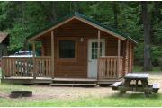
Alcohol and pets are prohibited at this campground. Camp office closes at 8pm on Sunday - Thursday nights.
Housatonic Meadows State Park, CT
Description
Book a Campsite at Housatonic Meadows State Park, CT
Description
Located in the rock-strewn valley of the Housatonic River, amid the rugged hills of the northwestern uplands, Housatonic Meadows is an ideal setting for a variety of outdoor recreational activities. Camping under the tall pines on the riverbank gives the overnight visitor a genuine back-to-nature feeling. The clear, cold river water also provides a fine opportunity for fly fishermen to test their skills on trout and bass. A two-mile stretch of river, including the park shore, is limited to fly fishing.
Geography:
Housatonic Meadows State Park contains 451 acres located in Sharon, CT, in the picturesque valley of the Housatonic River amid the rugged hills of the Northwestern uplands.
Recreation:
The clear, cold, river water provides a fine opportunity for fly fishermen to test their skills on the trout and bass. A two-mile stretch of river, including the park shore, is limited to fly fishing. Housatonic Meadows is an ideal setting for a variety of other outdoor recreational activities, including hiking, camping, canoeing and cross-country skiing.
Facilities:
Housatonic Meadow Campground offers 61 campsites, under tall pines on the banks of the Housatonic River. Additional park facilities include restrooms, showers, drinking water, gravel parking, and a pay telephone.
Nearby Attractions:
Nearby parks include Kent Falls State Park, in Kent, Lake Waramaug State Park, in Kent/New Preston, Macedonia Brook State Park, in Kent, and Mohawk Mountain State Forest, in Cornwall/Goshen.
Reservations must be made 1 Day(s) ahead of arrival and can be made up to 11 Month(s) in advance.
- Amphitheater
- Biking - Road
- Bird Watching
- Canoeing - River
- Comfort Station
- Dump Station
- Firewood
- First Aid Kit
- Fishing - Freshwater
- Flush Toilet
- Handicap Accessible
- Hiking
- Horseshoe Pits
- Ice Machine
- Kayaking
- Parking
- Photography
- Playing Fields
- Public Drinking Water Taps
- Rafting
- Ranger Station
- Recycling Center
- Restroom
- Scenic Overlook
- Showers
- Softball Field
- Telephone
- Tubing
- Walking
- Water Drinking
- Wildlife Viewing
- Campground Store
- Church
- Fishing Supplies
- Grocery Store
- Hospital
- Laundry
- Restaurant
41.88, -73.36
41°52'48"N, 73°21'36"W
From the north/Great Barrington/Pittsfield, MA: Travel south on Route 7 into Sharon, CT. The park is located along Route 7 in the Town of Sharon, approximately 3 miles south of the West Cornwall Covered Bridge, and approximately 2 miles north of the intersection with Route 4. From the south/Greater Danbury: Travel north on Route 7 into Sharon, CT. The park is located along Route 7, approximately 2 miles north of the intersection with Route 4, and approximately 3 miles south of the West Cornwall Covered Bridge. From the east/Hartford: Travel west on I-84, and take Exit 39. Continue west on Route 4. From Cornwall Bridge (after crossing the Housatonic River), turn north on Route 7. The park is located in Sharon, CT, along Route 7, approximately 2 miles north of the intersection with Route 4.
Nearby Parks


